Coming Soon … MPAS-Hydro!
A new project to couple the WRF-Hydro® routing modules to NSF NCAR's Model for Prediction Across Scales (MPAS)

The WRF-Hydro® team has kicked off a new project to couple the WRF-Hydro routing modules to NSF NCAR's Model for Prediction Across Scales (MPAS). The new "MPAS-Hydro" code will benefit the community through:
- Ability to directly predict flood, water supply, and other high-resolution hydrologic responses to weather and climate, and how these risks/resources are changing due to the changing global climate;
- Improved terrestrial boundary conditions for Earth system atmospheric (soil moisture, ET) and ocean (freshwater flows) component models due to more realistic lateral transport of surface and groundwater;
- New opportunities to evaluate MPAS for water forecasting and planning applications, including decision-relevant scales and metrics (e.g., reservoir inflows, flood frequencies and extents);
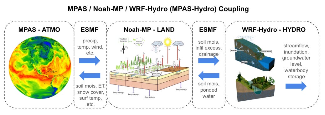
Technical Approach: MPAS is an Earth system modeling framework including atmosphere, ocean, ice, and land components. MPAS utilizes unstructured Voronoi meshes to allow quasi-uniform discretization of the sphere alongside local refinement. We will be leveraging the Earth System Modeling Framework (ESMF) model interoperability capabilities to interface between the MPAS atmospheric model, the Noah-MP land surface model, and WRF-Hydro terrain, channel, and reservoir routing modules.
Broader Impacts: More realistic representation of terrestrial hydrology in our Earth system models will improve our ability to understand and predict land-atmosphere feedbacks, while better representation of atmosphere and land dynamics in our hydrology models will open up new integrated approaches to address society's water challenges.
We expect the new capabilities to be available to the community in 2026.